North Cascades Wildflower Guide: Bloom Timing by Elevation and Best Trails
Last updated: March 2026
For most North Cascades wildflower trips, the real question is not which trail is prettiest. It is which elevation band is actually ready when you are driving SR-20. If you match your stop to the snowline, you can still get a good flower day even when the high passes are not ready yet.
Get the North Cascades newsletter if you want practical trip updates and new guide releases before your next SR-20 drive.
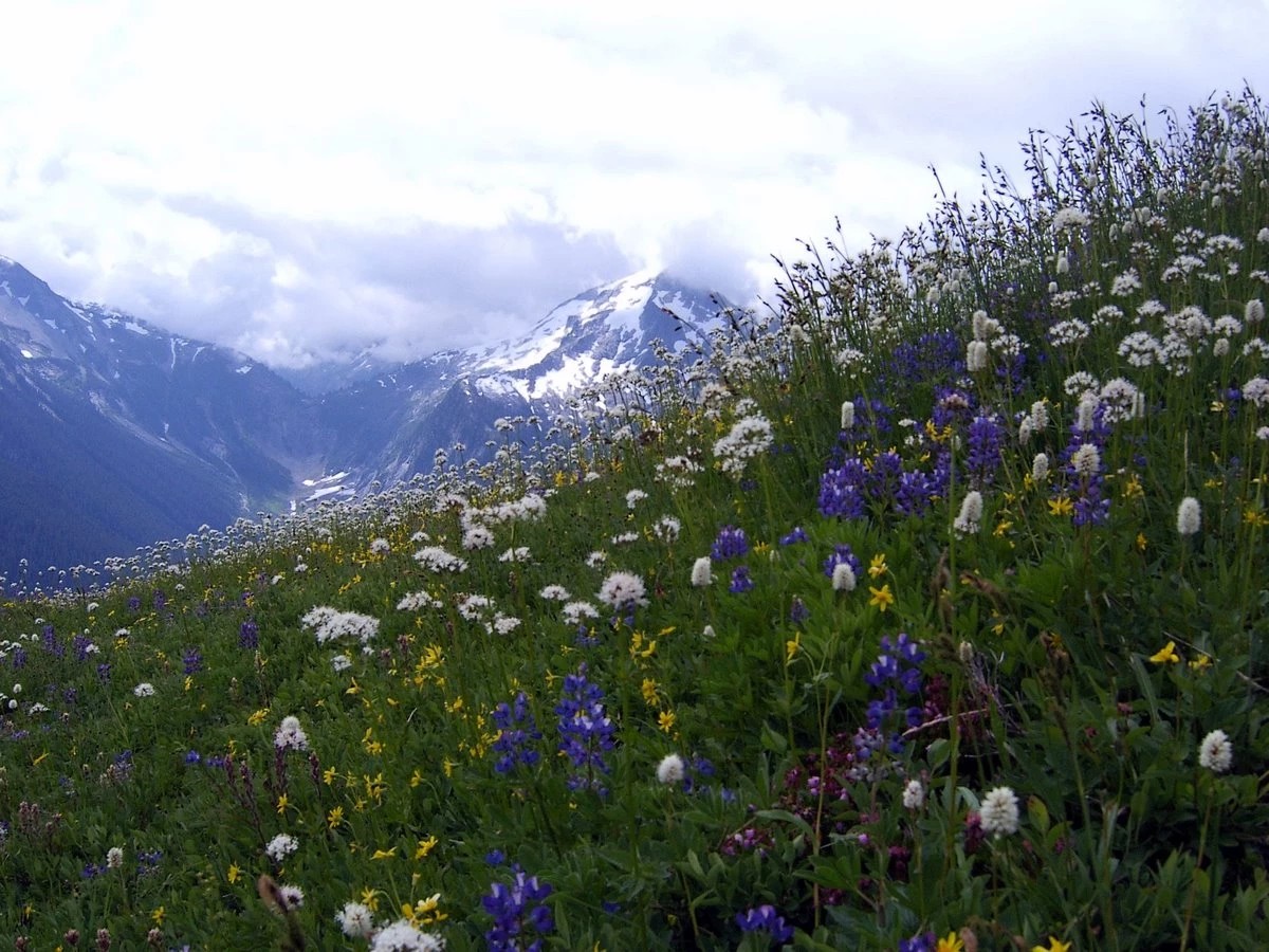
A profusion of wildflowers on Copper Ridge. Photo by NPS/Lin Skavdahl
Quick Decision Guide
Use this page by elevation, not by calendar month. Low forest flowers can start early in spring, while the alpine zone can stay late into summer once snow finally clears (bloom timing).
- Quick visit (and the high country is open): Go east of Diablo to Rainy Lake near SR-20 mile marker 158. It is the best short wildflower stop when you want paved access, a short walk, and a trailhead toilet instead of committing to a real hike (trail details).
- Half day (and you want the best balance): Choose Blue Lake east of Diablo and before Washington Pass. It gives you alpine flowers without the bigger commitment of Maple Pass, but it still needs the highway open and a Northwest Forest Pass (trail details).
- Full day (and you actually want the headline hike): Choose Maple Pass after Newhalem and well east of Diablo once melt-out is established. It beats Rainy Lake for bigger flower terrain, but only if your group is ready for a longer day and shared Rainy Pass parking pressure (trail details).
- Kids, less able, or a windy day: Pick Thunder Knob after Newhalem and west of Diablo near SR-20 mile marker 130 if the pass country is not worth the effort. It is easier logistically than Rainy Lake because it sits lower and starts on park-side access, but it is a backup flower plan, not the top alpine bloom play (trail details).
How bloom timing works on SR-20
Think in bands:
- In the lower forest corridor west of and around Marblemount, the first flowers can start as early as late February or March, with the most useful spring window usually running from April into May.
- Around Newhalem, Diablo, and other mid-corridor elevations, the better wildflower window usually shifts to May through July.
- Farther east at Rainy Pass and Washington Pass, the high-country bloom is typically a July through August play, and in lingering-snow years it can stretch into early September. (bloom timing).
The common mistake: People hear “peak wildflowers” and drive straight for the passes. That only works if snowmelt, highway access, and trail access line up on the same trip. If they do not, you waste half your day driving to a plan that is still buried or not worth the wind and cold (SR-20 status).
Use the corridor this way: target April to May for lower and mid-elevation flowers, start looking harder at June into July for the Diablo-to-Rainy zone depending on snow year, and treat July through August as the main window for Rainy Pass, Washington Pass, Blue Lake, and Maple Pass. Save bigger detours like Cascade Pass for when flowers are the main goal and you want a full hiking day, not just a quick highway stop
Best short flower stops and easier picks
Rainy Lake is the best short high-country answer after Newhalem and east of Diablo when you want flowers without a hard climb. The paved trail, accessible toilet, and short distance make it a stronger choice than Blue Lake for mixed groups, tired travelers, or anyone who just wants one reliable stop near Rainy Pass (trail details).
Thunder Knob is the best lower backup after Newhalem and west of Diablo if the high country is not ready. It beats Baker Lake Road for a same-day SR-20 stop because you do not need a true side-road detour, but the tradeoff is obvious: it is not an alpine flower meadow and should not replace Rainy Pass once the pass country is on (trail details).
Cutthroat Lake is a good pick east of Washington Pass near SR-20 mile marker 167 if you want a calmer feel than the Rainy Pass cluster and still want a real trailhead with a large lot and vault toilet. It beats Maple Pass when you want a simpler outing, but it does mean driving farther east and taking a short gravel spur road off the highway (trail details).
Best high-country flower hikes
Blue Lake is the best middle-ground hike east of Diablo and before Washington Pass when you want alpine flowers and a real payoff without turning the day into a long loop. It is usually the smartest recommendation for visitors who want one main wildflower hike, not the most famous hike. The tradeoff is that it still needs the high highway open and uses a Forest Service trailhead, so bring the right pass (trail details).
Maple Pass is the best choice only if flowers are the main event and your group is prepared for a bigger day. It earns that role because it gives you long stretches of open subalpine terrain, not just one lake or one viewpoint. It beats Blue Lake for a full flower day, but loses badly if anyone in your group only wanted a short stop or easy walk (trail details).
Cutthroat Pass via the Pacific Crest Trail can be a smart alternative east of Diablo when the Rainy Pass area feels too busy. It gives you high-country terrain with a different feel than Maple Pass, but it is still a real hike and should not be treated like a quick add-on after several other stops (trail details).
Tip: Rainy Lake and Maple Pass share the same general zone. If your group splits on energy after you arrive, send the easy-walk people to Rainy Lake and the strong hikers to Maple Pass instead of forcing one compromise plan.
Before you commit to a flower stop
Check the highway first. If SR-20 is still seasonally closed, every Rainy Pass and Washington Pass flower plan is off the table, no matter what photos you saw from another year (SR-20 status).
Check trail and road access next. Side-road plans after Marblemount and some higher trailheads change faster than casual visitors expect. A trail can be perfect on paper and still be the wrong choice that day because the access road, snow, or washouts have changed (trail conditions).
Bring the right parking pass. Rainy Lake, Blue Lake, Cutthroat Lake, and other Forest Service trailheads can require a Northwest Forest Pass, while trails that begin on National Park Service land do not use the same trailhead fee setup (fees and passes).
Handle fuel and downloads before Marblemount. Once you keep driving east, services thin out fast and cell service is not something to count on. This is one of the easiest mistakes to avoid on a flower day.
Do not ignore weather and smoke. Exposed flower hikes lose their value fast when wind, cold, or smoke flatten the experience. Lower forest options west of Diablo are often the smarter salvage plan on those days (forecast) (smoke map).
Related Guides
Conditions, access, snow, smoke, and parking change fast in the North Cascades. Recheck official sources before you commit to a flower stop or detour.