One-Day North Cascades Highway Itinerary: Best Stops in Order
Last updated: June 2026
CC BY-SA (Wikimedia Commons, Joe Mabel)
If you only do one thing: drive west to east, start with Newhalem and Gorge Creek Falls, then Diablo Lake Overlook, then continue to Ross Lake overlooks and Rainy Pass stops only if SR 20 is open. Start with Current Conditions and This Weekend’s Plan if your trip is coming up soon, then confirm official status with WSDOT SR 20 status, NPS road conditions, and the NPS highlight stops.
Before you drive Highway 20
This one-day route only works if the road, weather, visibility, services, and timing line up. Use these first if your trip is coming up soon or if you are deciding whether to make it a day trip or stay overnight.
Quick decision guide
Note: This guide is a one-day driving plan. Use the sections below to scale it up or down
Half-day, first time, minimal walkingNewhalem + Gorge Creek Falls + Diablo Lake Overlook, then turn back west if time is tight (stop list and mileposts on NPS) (NPS highlight stops). Use the North Cascades Without Hiking guide or Five Easy Walks in Marblemount and Newhalem if you want the lowest-effort version.
Full day, scenic focus
Plan A (below) stop order plus Ross Lake overlooks; add Rainy Lake only if the east side is open and you have time (Rainy Lake access details on WTA) (WTA Rainy Lake). Use the Rainy Pass Area Guide and Washington Pass Overlook guide if you are continuing past Diablo.
Family-friendly easy walk included
Build around Rainy Lake if SR 20 is open; WTA describes it as a wheelchair-accessible, paved one-mile (each way) trail starting at Rainy Pass Trailhead (parking guidance included) (WTA Rainy Lake). For mixed groups, compare this with Family-Friendly North Cascades and Accessible Walks Near Marblemount.
Shoulder season or winter risk
Assume partial closure is possible; NPS and WSDOT publish closure points and status, including winter closures between MP 134 and 171 in recent updates (check before you drive) (NPS road conditions) (WSDOT SR 20 status). See Plan B itinerary for backup options. Before committing, check the Seasonal Access Guide, Current Conditions, and Backup Plans.
Build This Trip
Plan A: best stop order (full scenic day)
- Use this when: SR 20 is open through Rainy Pass/Washington Pass and visibility is decent (check official source) (WSDOT SR 20 status) (NPS road conditions).
- Goal: hit the highest-payoff stops early, use lower-effort backups when parking is crowded, and avoid backtracking.This is a full 10-14 hour trip including drive time and time at each stop.
- Tip: plan food and fuel before you commit to the corridor. NPS notes service scarcity in the park complex and directs visitors to gateway towns. Top off on gas and snacks at Marblemount before you enter the park complex.
- North Cascades Visitor Center area (first reset stop) - NPS lists it as a core highlight at Mile 119.9 (good for quick orientation and weather check) (Check visitor hours)
- Newhalem (easy walking + pacing) - NPS lists Newhalem at Mile 120.5 and describes easy trails and creek/forest walking options (use this to absorb schedule slip) (NPS highlight stops).
- Tip: use Newhalem early as your “time buffer” stop. It is the easiest place to shorten or expand without ruining the rest of the route.
- Gorge Creek Falls (fast, high payoff) - NPS lists it at Mile 123.4 with a short interpretive walk to an overlook (do this even on tight days) (NPS highlight stops).
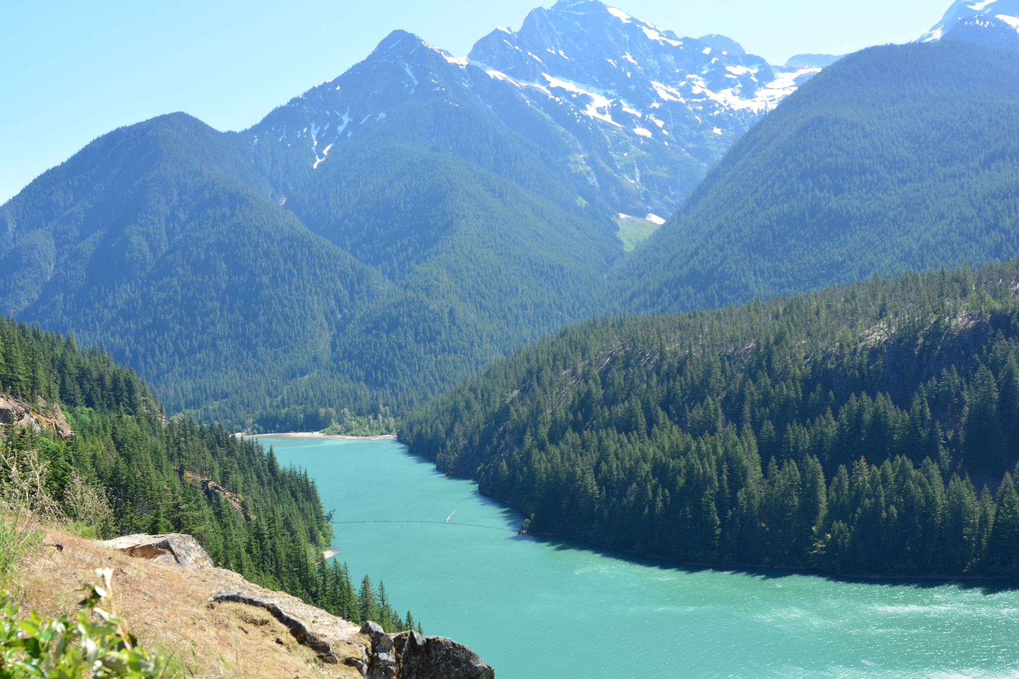
- Diablo Lake Overlook (signature stop) - NPS lists it at Mile 131.7 (prioritize, but do not wait forever if parking is jammed) (NPS highlight stops).
- Tip: if Diablo Lake Overlook parking is frustrating, do not stall your whole day. Run Happy Creek and Ross Lake overlooks, then retry Diablo later on your way back west.
- Happy Creek Forest Walk (crowd-proof backup) - NPS lists it at Mile 134.3 (use this if Diablo is packed or visibility is mixed) (NPS highlight stops).
- Ross Lake Overlooks (quick scenic pullouts) - NPS lists overlooks at Mile 136 (good when you need to keep moving) (NPS highlight stops).
- Rainy Pass Trailhead to Rainy Lake (easy “real hike” stop) - WTA provides parking guidance (park on the west side of the highway, trail starts at the south end of the lot) and describes it as a paved, wheelchair-accessible one-mile trail to the lake (each way) (WTA Rainy Lake). Use the Rainy Pass Area Guide to compare Rainy Lake, Maple Pass, Lake Ann, and nearby trailhead options.
- Washington Pass Overlook (if still clear and open) - confirm SR 20 status first; NPS notes Washington Pass is the highway high point at 5,477 feet, which is why conditions change quickly up there (NPS road conditions).
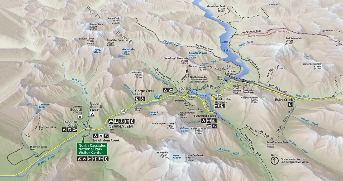
Map credit: National Park Service (North Cascades National Park), ‘Map of State Route 20’
If this feels like too much for one day
This route can turn into a 10- to 14-hour day once you include drive time, stops, parking, weather delays, food, and the return drive. If that sounds too tight, turn it into an overnight trip instead.
Plan B: closures, weather shift, or parking full
- Use this when: SR 20 is closed past the Diablo/Ross Lake area, the east side is not reachable, or visibility is collapsing.
- First action: check official status and closure point (NPS and WSDOT both publish this; do not rely on social posts) (NPS road conditions) (WSDOT SR 20 status).
- Visitor Center + Newhalem first - get your baseline scenic value early while conditions are stable (Check visitor hours)
- Gorge Creek Falls - short stop that still works in mixed weather (NPS highlight stops).
- Diablo Lake Overlook attempt - quick check; if it is socked in or parking is jammed, do not wait.
- Happy Creek + Ross Lake overlooks - shaded, lower-effort stops that salvage the day when big views are failing (NPS highlight stops).
- Turn back west earlier - save your time for a better visibility window later rather than pushing deeper into a closed corridor.
- Tip: WSDOT and NPS have listed closures between MP 130 and 171 in recent winter status updates (if you're not visiting in peak summer, check official source the day you drive) (WSDOT SR 20 status) and (NPS road conditions).
If the full route falls apart, use Backup Plans, the Baker Lake Area Guide, or North Cascades Without Hiking instead of forcing a bad high-country day.
Best stops (what to do and when to skip)
Newhalem and the Visitor Center area
- Do it when: you need a reliable first stop, you are behind schedule, or weather is uncertain.
- Skip it when: you are truly speed-running and visibility is perfect (rare). Even then, it often prevents later chaos.
- Why it matters: NPS lists the Visitor Center at Mile 119.9 and Newhalem at Mile 120.5 as core highlights along SR 20
- Plan practical stops: use Newhalem Area Services and the Restroom Stops guide before counting on facilities deeper in the corridor.
Gorge Creek Falls
- Do it when: you want maximum payoff per minute.
- Skip it when: you are already cutting the day down to one stop only.
- Why it matters: NPS describes a short interpretive trail to an overlook with waterfall, gorge, and dam views (Mile 123.4) (NPS highlight stops).
Diablo Lake Overlook
- Do it when: visibility is decent. This is the classic “postcard” stop.
- Skip it when: clouds/smoke are fully blocking the lake and you are burning time waiting for parking.
- Why it matters: NPS lists Diablo Lake Overlook at Mile 131.7 (NPS highlight stops).
Happy Creek Forest Walk and Ross Lake Overlooks
- Do it when: big viewpoints are crowded or visibility is inconsistent.
- Skip it when: you are already getting perfect views and have limited time, but keep at least one as your “backup anchor.”
- Why it matters: NPS lists Happy Creek Forest Walk at Mile 134.3 and Ross Lake overlooks at Mile 136 (NPS highlight stops).
Rainy Pass and Rainy Lake
- Do it when: SR 20 is open through Rainy Pass and you want an easy, accessible “real trail” stop.
- Parking approach: Parking fills fast! Arrive early if you want a premium spot, otherwise WTA says to park on the west side of the highway at Rainy Pass Trailhead and start from the south end of the parking lot (WTA Rainy Lake).
- Skip it when: the highway is closed beyond the west-side corridor or weather is turning fast (check official source) (WSDOT SR 20 status).
- Compare nearby options: use the Rainy Pass Area Guide if you are deciding between Rainy Lake, Lake Ann, Maple Pass, and nearby stops.

CC BY-SA 4.0 (Wikimedia Commons)
Common mistakes (and fixes)
- Mistake: driving out expecting Washington Pass when SR 20 is closed.
- Fix: check Current Conditions, WSDOT, and NPS before you leave and again that morning (WSDOT SR 20 status) (NPS road conditions).
- Mistake: letting Diablo Lake Overlook parking determine your whole day. Fix: run Happy Creek and Ross Lake overlooks first, then retry Diablo later (NPS stop list) (NPS highlight stops).
- Mistake: trying to do every stop plus a big hike in one day.
- Fix: pick one “walk” stop, such as Rainy Lake or a Newhalem-area stroll, and keep everything else as viewpoints. If that still feels too full, use the Two-Day Itinerary or Where to Stay.
- Mistake: arriving without food/fuel and assuming the park corridor will have services.
- Fix: plan your last gas and supplies before heading east of Marblemount, and check the Restroom Stops guide before assuming facilities will be easy.
- Mistake: ignoring parking approach at Rainy Pass.
- Fix: follow WTA’s parking guidance for Rainy Lake (west side of highway; trail at south end of lot) (WTA Rainy Lake).
- Tip: if the day is going sideways, convert it into a “west-side greatest hits” loop using Backup Plans, North Cascades Without Hiking, or the This Weekend’s Plan instead of pushing deeper into worsening conditions.
Next step
Use these if you are turning this itinerary into an actual trip plan.
Sources
Disclaimer: Conditions, closures, parking availability, and visibility change quickly in the North Cascades. Verify current status with NPS and WSDOT before travel.