North Cascades Backup Plans: Road Closures, Rain, Smoke, and Failed Destinations
Last updated: August 2026
The right North Cascades backup depends first on where you are starting. A visitor approaching from Seattle or the Skagit Valley has different reachable options than a visitor already in Winthrop, Mazama, or Twisp. Start with your current side of the mountains, then identify what actually failed: the cross-pass connection, one destination, a side road, the weather, smoke, or parking.
A closed route across Washington Pass does not automatically mean the west-side corridor is closed, pass country is unreachable from the east, or the Methow Valley is unavailable as a destination. It means the two sides may no longer connect by SR-20. Check Current Conditions before choosing a recovery path.
Get North Cascades road, smoke, weather, and backup-planning updates by email
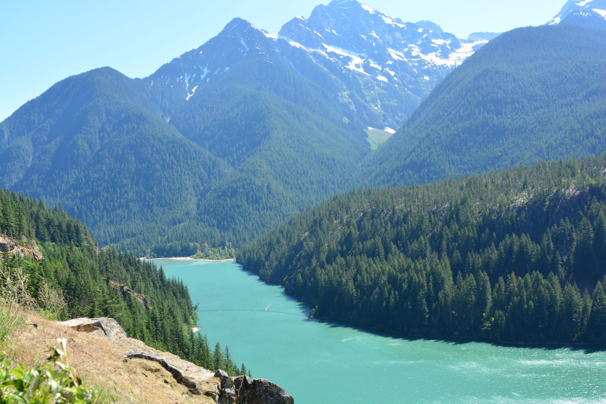
View of Diablo Lake from the SR-20 overlook east of Newhalem - Joe Mabel CC BY-SA 4.0
Start with location, then failure mode
First decide whether you are on the west side, approaching pass country from the east, or already committed to a Methow Valley stay. Then ask whether the problem is only the through-route or whether the destination itself is inaccessible.
Quick Decision Guide: Which Side Are You On?
You are west of the disruption
This includes visitors approaching from Seattle, Burlington, Sedro-Woolley, Concrete, Rockport, or Marblemount. If the cross-pass route fails, use a west-side recovery path. Newhalem, Diablo-area stops, or Cascade River Road remain options only when their own access is confirmed. Baker Lake is relevant only as a deliberate west-side pivot from the Concrete or lower-Skagit side.
You are approaching pass country from the east
This includes visitors coming from Mazama, Winthrop, Twisp, Okanogan, or the lower Methow. A closed through-route does not by itself prove that every Rainy Pass or Washington Pass destination is inaccessible from the east. Confirm the exact closure point. If the destination lies beyond it, retreat toward Mazama and the Methow rather than trying to replace it with a west-side stop.
You are already staying in the Methow Valley
A closed crossing is usually a route problem, not the end of the booked trip. Keep the recovery plan inside Mazama, Winthrop, Twisp, Pearrygin, Sun Mountain, or other confirmed valley locations. Use the future Methow Valley Smoke, Weather, and Closure Plan B guide when weather, smoke, or access changes a trip that is already based east of the crest.
Closed Cross-Pass Route vs Inaccessible Destination
These are different failures and need different responses.
The cross-pass route is closed: SR-20 does not connect the west side and east side through the mountains. The correct response is usually to stay on your current side and rebuild the trip there. Do not assume that every place on both sides is closed.
Your destination is inaccessible: The road, trailhead, campground, overlook, or side road you intended to use cannot be reached from your side. Replace that destination with another confirmed option on the same side of the closure.
Example from the west: If the pass is closed but Newhalem remains reachable, a west-side visitor may still have a Newhalem day. If access ends before Newhalem, that same visitor needs a lower west-side plan around Rockport, Concrete, or a separately verified Baker Lake outing.
Example from the east: If the highway does not cross the crest but an east-side closure point still allows access to a specific Washington Pass-area stop, that stop may remain usable from Mazama. If the closure sits before it, the recovery path is back toward Mazama, Winthrop, or Twisp—not across the mountains to Newhalem.
Best first check: Use the SR-20 access tracker and the official WSDOT North Cascades Highway report to identify the actual reachable segment.
Recovery Path 1: You Are on the West Side
Use this branch if you are approaching from Seattle or the Skagit Valley, or are already based in Concrete, Rockport, Marblemount, Newhalem, or another west-side location.
If the cross-pass route is closed
Stop planning a through-drive to Washington Pass, Mazama, Winthrop, or Twisp by SR-20. Keep the day west of the closure. The deepest useful destination depends on the live gate, storm damage, snow, rockfall, fire restrictions, and park access.
Reachable recovery sequence: start with Concrete or Rockport for services and low-commitment stops, continue to Marblemount and Newhalem only if access is confirmed, and use Diablo-area stops only when the official closure point allows them.
If Newhalem or Diablo is inaccessible
Do not keep replacing one blocked interior stop with another stop farther east. Move the trip back toward Rockport and Concrete. Rockport State Park, river-valley stops, town services, and a deliberately planned Baker Lake outing can preserve the day without crossing the failed point.
Baker Lake rule: Baker Lake is a west-side replacement for visitors already near Concrete or the lower Skagit corridor. It is not a practical fallback for someone stranded east of Washington Pass, and it is not an automatic substitute unless Baker Lake Road and the intended facility are independently confirmed.
If Cascade River Road is the failed destination
Stay on the main Highway 20 corridor. Use Marblemount, Newhalem, short park stops, Rockport, or Concrete according to current access. Do not replace one uncertain side road with another side road simply because it appears nearby on a map.
If rain is the problem
Keep the plan short and stacked. Newhalem is the strongest interior rainy-day anchor when reachable because short walks and visitor facilities are close together. Gorge Creek Falls, Diablo Lake Overlook, and Happy Creek only belong in the plan when both road access and visibility justify continuing east.
If smoke is the problem
Check west-side air quality before adding distance. Reduce exertion first. If the west side is unhealthy or an active fire blocks the corridor, a town, lodging, or cancellation decision may be more appropriate than searching for a farther trail. Do not assume the east side is available or clearer when the crossing is closed.
Recovery Path 2: Pass Country From the East
Use this branch if you are approaching Rainy Pass or Washington Pass from Mazama, Winthrop, Twisp, or another east-side route.
If the highway will not cross the mountains
Do not interpret “closed across the pass” as a complete answer for east-side access. Confirm the exact eastern closure point. Some years or disruptions may leave a portion of pass country reachable from the Methow even though a west-to-east crossing is impossible. Evergreen copy should never promise which stop remains open.
Use only destinations before the confirmed closure: Washington Pass Overlook, Cutthroat, Blue Lake, Rainy Pass, or another pass-country stop belongs in the recovery plan only when the official status shows it is reachable from the east.
If the planned pass-country destination is beyond the closure
Turn the day back toward Mazama and the Methow Valley. Do not recommend Newhalem, Diablo Lake, Rockport, Concrete, or Baker Lake unless the visitor deliberately chooses the long alternate highway route around the mountains as a completely new trip.
Closest recovery layer: Mazama and the upper valley. Broader-services recovery layer: Winthrop. Longer-stay and practical-services layer: Twisp.
If rain, wind, snow, or poor visibility ruins the high-country stop
Descend toward Mazama rather than searching for another exposed overlook or alpine trailhead. A low-effort upper-valley or town plan reduces elevation, driving risk, and the chance that the replacement fails for the same weather reason.
If smoke is the problem
Compare pass-country and valley air quality before moving. Smoke can pool in the Methow or cross the crest, so “drive downhill” and “drive west” are not universal answers. Reduce exertion and use the Methow Valley Smoke, Weather, and Closure Plan B guide when the trip is already committed to the east side.
If parking is full
Do not recommend another activity that depends on the same full parking complex or the same blocked approach. Choose an independently accessed stop that remains before the closure, or return toward Mazama and the valley.
Recovery Path 3: You Are Already in the Methow Valley
Use this branch when lodging, family plans, or the trip itself are already based in Mazama, Winthrop, Twisp, or the lower Methow.
If the cross-pass route is closed
Keep the trip in the Methow Valley. The closure removes a west-side add-on or a through-drive; it does not erase the valley as a destination. Do not replace the day with Newhalem, Diablo Lake, Rockport, Concrete, or Baker Lake unless the visitor intentionally undertakes the long alternate road route around the mountains.
If Washington Pass or Rainy Pass is inaccessible
Rebuild the day around the valley rather than waiting at the closure. Mazama works best for an upper-valley, outdoor-oriented recovery. Winthrop offers the broadest mix for families and mixed-interest groups. Twisp is strongest for practical services, arts, food, and a longer self-catering stay.
If rain or poor mountain weather is the problem
Separate the valley forecast from the pass forecast. A bad high-country day may still allow a useful lower-valley day, but the replacement should be chosen from confirmed local activities rather than assumed from seasonal reputation.
If smoke or wildfire changes the trip
Use air quality and official fire restrictions before choosing an activity. A visibility problem and a health problem are not the same. When air quality is poor, reduce exertion, prioritize indoor or town-based time, and be willing to shorten the trip. The detailed handoff for booked east-side guests is the future Methow Valley Smoke, Weather, and Closure Plan B guide.
If a Methow side road or trailhead is inaccessible
Do not substitute another destination that uses the same closed forest road, fire closure, snow zone, or rough-road approach. Return to the paved valley system and choose a separately accessed town, park, trail, or low-effort stop after checking its current status.
Reachable recovery hierarchy
- Mazama: best when the group is already in the upper valley and wants the shortest retreat from pass country.
- Winthrop: best for families, food, lodging, visitor services, and mixed-interest recovery.
- Twisp: best for groceries, practical services, arts, and a longer flexible stay.
- Valley parks and recreation areas: use only after checking the specific facility, road, fire, weather, and seasonal status.
Failure-Mode Rules That Apply Everywhere
Rain and poor visibility
Shorten the day before adding distance. Use lower-elevation, car-adjacent, town, visitor-center, or short-walk options on your current side. Do not replace one clouded-over high point with another high point exposed to the same weather.
Smoke
Start with air quality and health, not the promise of a clearer photograph. Smoke can differ between the west side, pass country, and the Methow, but it can also affect all three. Check AirNow Washington, the Washington Smoke Blog, and official fire or closure notices before driving toward another region.
Active fire or agency closure
Do not treat a closed trail, road, campground, or recreation area as a weather inconvenience. Follow the closure boundary and choose a destination outside the affected access system.
Parking failure
A real parking backup must use a different lot or access point. Another trail sharing the same full lot is not a fallback. A distant cross-corridor destination is a regional reroute, not a same-morning parking alternative.
Side-road failure
A side road has its own status. Highway 20 being open does not prove Cascade River Road, Baker Lake Road, or a Methow forest road is usable. Check the road and the intended destination separately.
Side Roads Are Regional, Not Universal Backups
The safest backup reduces uncertainty and remains on the visitor's reachable side.
Cascade River Road: west-side only. Use it when approaching from Marblemount and only when its own road and destination status are confirmed. It is not a fallback for a visitor in the Methow.
Baker Lake Road: west-side only. It is most logical from Concrete or the lower Skagit approach. It is a separate outing, not an east-side pass-country or Methow fallback.
Pass-country access from Mazama: east-side only when the intended stop lies before the confirmed eastern closure. It is not proof that the road crosses to Newhalem.
Methow forest roads: east-side local options with their own snow, fire, surface, vehicle, and seasonal constraints. They should never be presented as automatic replacements for a closed paved highway or another failed forest road.
Rule of thumb: If a replacement requires crossing the closed crest, passing the same closure, or taking another unverified side road, it is not a dependable backup.
Choose an Overnight Base That Stays Reachable
When the next day's access is uncertain, choose lodging on the same side as the most likely reachable plan.
Concrete: best west-side flexibility when you need services, lower-corridor options, and a possible Baker Lake pivot.
Rockport: best for a quieter west-side reset without committing as far east as Marblemount.
Marblemount: best when Newhalem, the park corridor, or Cascade River Road remains the likely next-day goal and current access supports that choice.
Mazama: best east-side position for pass country when the reachable segment and weather support it.
Winthrop: best all-around Methow recovery base for families, food, lodging, and mixed interests.
Twisp: best practical Methow base for longer stays, self-catering, and broader service needs.
Do not switch sides casually: when the cross-pass route is closed, moving from a west-side base to a Methow base—or the reverse—requires the long alternate road system around the mountains. That is a new regional trip, not a nearby lodging adjustment.
Final Checks Before You Drive
Check only the sources that control your side and destination.
- All trips: start with Current Conditions for separate west-side, pass-country, and Methow interpretation.
- Cross-pass or partial-access question: use the WSDOT North Cascades Highway report.
- West-side park roads and destinations: use the NPS road conditions page.
- West-side Forest Service roads or Baker Lake: use Mt. Baker-Snoqualmie current conditions.
- Pass country or Methow forest destinations: follow the relevant Okanogan-Wenatchee National Forest or local land-manager alert linked from Current Conditions.
- Smoke: use AirNow Washington, the Washington Smoke Blog, and official fire-closure sources.
- Weather: compare the forecast for your valley or town with the mountain-zone forecast. Conditions at Winthrop, Newhalem, and Washington Pass are not interchangeable.
Final test: Can you reach the replacement without crossing the closed route, passing the failed access point, or depending on the same weather, fire, parking, or side-road problem? If not, choose another fallback.
Related Guides
Conditions can change quickly. Use this page for geographic recovery logic, then verify the exact road, closure point, destination, weather, smoke, fire, parking, and side-road status before driving.