
Maple Pass Loop Trail Guide: Parking, Direction, Season, Larches, and Crowd Strategy
Last updated: April 2026
Maple Pass Loop is a full-day Highway 20 hike from the Rainy Pass area, east of Newhalem and west of Washington Pass. It is best for hikers who want one serious high-country objective, but it is a poor choice if you are starting late, skipping fuel and food stops, or trying to add Cascade River Road or Baker Lake Road to the same day.
For weekly road, smoke, and trip-planning updates, sign up for the Cascades Field Guide newsletter.
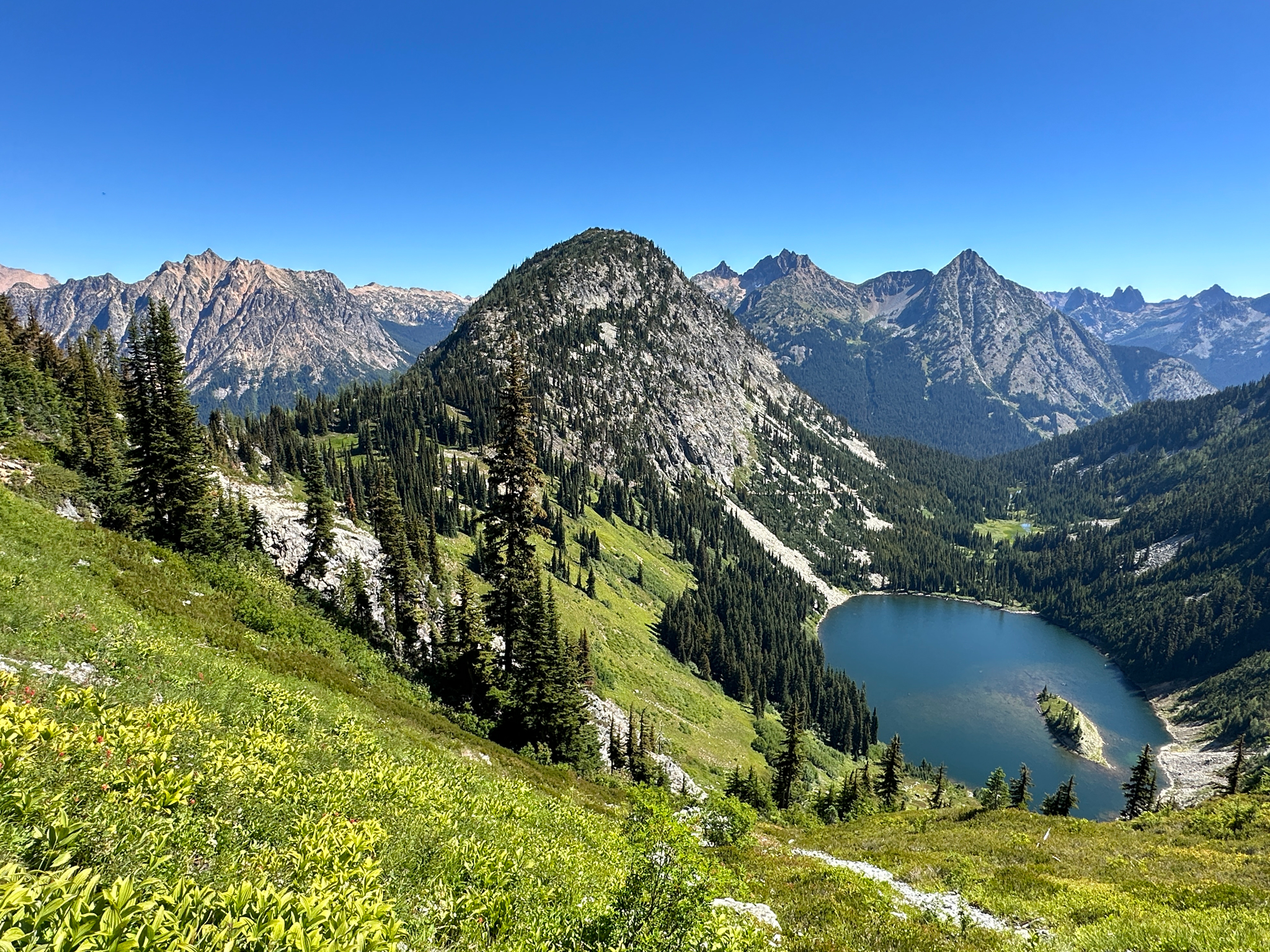
Maple Pass trail and alpine ridgeline in the North Cascades | CC0 1.0 Public Domain
Quick Decision Guide
Choose Maple Pass Loop if you want one major hike to anchor your Highway 20 day. Do not treat it like a quick stop between Diablo Lake and Washington Pass.
- Best fit: Strong day hikers with an early start, stable weather, and enough time to make Rainy Pass the main event.
- Best season: Usually summer into early fall, after trail snow has melted and before fall storms or the SR-20 winter closure cut off access.
- Larch season: Late September into early October is the usual target, but it brings the worst parking pressure and the highest chance of cold weather changes.
- Direction: Clockwise is the better default if you want the steeper work earlier and a more controlled finish.
- Backup move: If parking is full or weather is turning, use Rainy Lake or Washington Pass Overlook instead of forcing the loop.
Check the North Cascades This Weekend update before you drive. Maple Pass is too far up the corridor to discover a road, smoke, or weather problem after Newhalem.
Where Maple Pass Fits
Maple Pass Loop starts from the Rainy Pass area on Highway 20. For most west-to-east visitors, that means you pass Marblemount, Newhalem, Diablo Lake, and the Ross Lake corridor before reaching the trailhead.
This location changes the whole day. Maple Pass is not a Marblemount-area hike, even though many visitors sleep or buy supplies there. It is a Washington Pass-zone hike that uses the high section of SR-20 as its access road.
Why here: Maple Pass beats shorter stops like Washington Pass Overlook when your goal is a real alpine loop, not a viewpoint. The tradeoff is time, parking risk, and weather exposure. Washington Pass Overlook is easier to add to a road trip. Maple Pass needs the day built around it.
If you are trying to fit Maple Pass into a wider trip, use the Two-Day North Cascades Itinerary to avoid building a day that looks possible on a map but fails on the ground.
Parking, Passes, and Last Services
The Rainy Pass trailhead has limited parking, vault toilets, picnic tables, and no potable water. The same trailhead area serves Rainy Lake, Lake Ann, and Heather-Maple Pass Loop, so it is not just Maple Pass hikers using the lot.
Parking: If the lot is full, do not build your plan around circling. The Forest Service warns that parking is very limited, fills quickly, and visitors should choose another hike if parking is full. Blocking the roadway or emergency access is not a backup plan.
A recreation pass or day-use payment is required at this site. Accepted passes include the Northwest Forest Pass, Interagency Recreation Passes, and digital day pass options. Check the current Rainy Pass site page before you go because fee and payment details can change.
Before Marblemount: Handle fuel, food, and basic supplies before you commit to the high corridor. Once you pass Marblemount and Newhalem, the trip becomes less flexible. Use the Last Gas and Supplies guide if you are not sure where to stop.
Download maps before you leave the lower corridor. Cell service becomes unreliable through parts of the Highway 20 mountain corridor, and you should not depend on your phone to solve trailhead, weather, or route questions after you are already near Rainy Pass.
Which Direction to Hike
The loop can be hiked either direction, but the choice should be based on your group and conditions, not just views.
Clockwise: This is the better default for many visitors because it puts the steeper work earlier in the day. That matters if you want to avoid saving the harder push for tired legs.
Clockwise also keeps Rainy Lake as an easy early split point. If someone in your group realizes the full loop is too much, Rainy Lake is the clean bailout before the day becomes more committed.
Counterclockwise: This direction gives a more gradual build from the Lake Ann side. It can feel better for hikers who prefer a steadier climb, but you should still be comfortable finishing a long descent after the high point.
If there is lingering snow near the pass, direction matters less than judgment. Steep snow or icy tread can turn a popular loop into a bad idea. Check recent trail reports and turn around if conditions are beyond your group.
Season, Snow, and Larches
Maple Pass depends on two separate access questions. First, SR-20 must be open to Rainy Pass. Second, the trail itself must be in safe condition.
Access: SR-20 closes seasonally across the high passes because of winter conditions and avalanche risk. Rainy Pass and Washington Pass are inside the closure zone when the high highway is closed, so Maple Pass is not a winter road-access hike.
Do not assume an open highway means a snow-free trail. Maple Pass reaches high terrain, and snow can linger above the trailhead after the road opens. In fall, the reverse can happen: the road may still be open while early snow makes the loop more serious.
Larches: Late September into early October is the usual planning window for golden larches. That window is short, crowded, and weather-sensitive. If larches are the reason for your trip, you need an early start and a backup plan.
Heavy rain, smoke, or cold wind can make Maple Pass a poor choice even when the trail is technically open. Check the Seasonal Access Guide before committing to a high-country hike during shoulder season.
Crowd Strategy
Maple Pass is one of the most pressure-sensitive hikes on Highway 20. The trail is popular, the trailhead serves more than one destination, and fall larch weekends concentrate demand into a short window.
Best move: Start early enough that parking is part of the plan, not a hope. A late start can still work on quieter days, but on summer weekends and larch weekends it becomes a major gamble.
If Rainy Pass is full, switch plans quickly. Rainy Lake is the easiest nearby fallback from the same area if parking is available and your group needs a shorter outing. Washington Pass Overlook is the better choice if you still want a high-country stop without committing to a long hike.
Do not keep pushing east or west without knowing your next stop. After Newhalem, the corridor gives you fewer services and fewer easy resets. A full lot at Rainy Pass should trigger Plan B, not a long delay.
Plan A and Plan B
Plan A: Make Maple Pass the main hike, then add only one short SR-20 stop if your group still has time and energy. Washington Pass Overlook works well because it is nearby and does not require turning the day into a second hike.
If you are driving west to east, this means supplies before Marblemount, a restroom stop before or at the trailhead, Maple Pass as the main event, then a short Washington Pass-area stop afterward if conditions are still good.
Plan B: If the lot is full, weather is poor, or the group is not ready for the full loop, choose a shorter nearby option. Rainy Lake is best for a lower-commitment walk from the same trailhead area. Washington Pass Overlook is best when you want a short high-country stop with less effort. Blue Lake or Cutthroat-area hikes may fit a separate hiking day, but do not use them as automatic backups if their parking or conditions are also stressed.
Cascade River Road and Baker Lake Road are not simple Maple Pass add-ons. Cascade River Road branches from the Marblemount area before the long climb east on SR-20. Baker Lake Road sits on a different side route. Both can be good trip choices, but they belong in a different day structure.
If you are comparing Maple Pass with Cascade Pass, read the Cascade Pass and Sahale Arm Guide. Cascade Pass has its own road-access, parking, and permit issues, and it should not be treated as a quick substitute.
If your group decides against the full loop but still wants a short stop near the high pass, use the Washington Pass Overlook Guide to keep the day from becoming overbuilt.
Sources
- Trail stats, pass requirement, route notes, and recent trail reports: WTA Maple Pass
- Rainy Pass trailhead access, parking, fees, restrictions, toilets, and water availability: Rainy Pass Picnic Site
- Current SR-20 pass status: WSDOT North Cascades Highway
- Seasonal SR-20 closure context: WSDOT Closure Notice
- Point weather near Rainy Pass: Rainy Pass Forecast
- Smoke and air quality checks: AirNow Fire and Smoke Map
Related Guides
Conditions change quickly on Highway 20 and near Rainy Pass. Check road status, trail reports, weather, smoke, and current pass rules before leaving cell service or committing to the full loop.
